

A site can look straightforward from the road and still hide the exact problem that burns time later. A drainage path is steeper than expected. A stockpile volume is off. A grading assumption gets carried into design, then corrected in the field when equipment is already mobilized and everyone is paying for the delay.
That’s why Drone Photography for Site Surveying matters so much right now. For architects, developers, and contractors, the value isn’t just that a drone flies overhead and takes attractive aerials. Its key value is that the same flight can produce usable project intelligence and, when handled by someone who understands architectural imagery, visuals that communicate the site with clarity and intent.
From my side of the industry, that combination is what makes the tool powerful. A survey flight can support planning, coordination, and progress review. It can also help clients see the site as a design story instead of a set of disconnected constraints. Good drone work does both. It measures accurately, and it frames the project in a way that helps teams make decisions.
From Ground Guesswork to Aerial Intelligence
The usual failure point shows up before anyone calls it a failure. A team is reviewing a site plan in the studio, the contours look serviceable, and the base information appears complete. Then construction starts, a drainage route behaves differently than expected, access is tighter than the drawings suggested, or an owner asks for a clear visual update and gets records that are accurate but hard to read outside a surveying context.

Drone surveying improves that situation because it records the entire site as both measured information and readable imagery. For architects, developers, and contractors, that matters less as a novelty than as a way to shorten the distance between raw conditions and a decision. A good aerial survey does not leave the project team translating between technical data on one side and presentation material on the other. It produces a common visual reference everyone can work from.
From above, the site starts to read properly.
Grade transitions become visible across the whole parcel. Drainage patterns show up in relation to paving, vegetation, and disturbed ground. Staging areas, haul routes, and pinch points are easier to assess when they are seen in plan and in context. Progress documentation also becomes more useful because each phase is tied back to the full site rather than a disconnected set of ground photos.
That broader view has a safety and logistics benefit too. Transportation agencies and infrastructure teams use aerial survey methods to document active corridors and large sites while reducing the need to place crews in hazardous positions. The practical value is straightforward. Better visibility early in the job usually means fewer assumptions carried forward into design, procurement, and field coordination.
From my side of the work, the key advantage is not only accuracy. It is clarity. An orthographic survey image gives a team a dependable base for measurement and markup. A well-composed oblique aerial can explain frontage, neighboring structures, tree cover, setbacks, and approach sequence in a single frame. One helps the team verify. The other helps the team see.
Practical rule: The best site survey image answers a project question clearly enough that the architect, contractor, and client can all act on it.
That blend of precision and legibility is what turns drone photography from a flying camera into a design tool. The survey informs coordination. The image informs judgment. On strong projects, those two jobs happen in the same flight.
The Three Essential Drone Survey Deliverables Explained
When clients say they want “drone photos,” they often mean three very different outputs. The camera is only the beginning. What matters is the processed deliverable and whether it fits the job at hand.

Orthomosaic maps
An orthomosaic is often the first deliverable recognized. Think of it as a highly corrected, high-resolution aerial base map of your property. Individual images are stitched together and geometrically corrected so the scale is consistent across the site.
That consistency matters. A regular aerial photograph can look persuasive while still distorting distance and angle. An orthomosaic is built for measurement, markup, and coordination. Architects use it to understand site boundaries, paving, vegetation, and adjacent conditions. Contractors use it to verify what has been built. Developers use it for due diligence, presentations, and planning discussions.
From a visual storytelling standpoint, this is the image that turns a complicated site into something everyone can read in seconds.
Digital elevation models
A digital elevation model, or DEM, answers a different question. It deals with height, slope, and terrain behavior. If the orthomosaic is your site atlas, the DEM is your terrain logic.
A DEM is especially useful when the conversation shifts to grading, drainage, cut and fill, or where water is likely to move. It takes what can feel abstract in contour lines alone and turns it into a usable terrain layer. For design teams, that means fewer assumptions. For field teams, it means a clearer basis for planning.
3D models and point clouds
The most powerful output for many AEC workflows is the 3D model, often built from a point cloud. Such outputs transform Drone Photography for Site Surveying from “aerial coverage” into a digital site representation you can measure, inspect, and integrate into design software.
According to SurveyDrones’ guide to drone survey data, drone-generated point clouds from photogrammetry are the foundational dataset and can produce densities of 100-500 points/m². With RTK/PPK drones and ground control points, these datasets achieve centimeter-level absolute accuracy and can outperform traditional methods in speed by 5-10x for large sites.
That matters because point clouds don’t just “show” the site. They let teams interrogate it.
A good point cloud is less like a photograph and more like a measured spatial memory of the site.
Which deliverable to ask for
The right output depends on what decision you’re trying to make.
| Deliverable | Description | Primary Use Case | File Format / Software |
|---|---|---|---|
| Orthomosaic | Georeferenced stitched aerial image with consistent scale | Site overview, markup, planning, existing conditions review | GeoTIFF, GIS viewers, CAD overlays |
| Digital Elevation Model | Terrain surface model showing elevation changes | Grading, drainage planning, cut-and-fill analysis | DEM raster formats, GIS, Civil design tools |
| 3D Models Point Clouds and Meshes | Dense 3D reconstruction of the site surface and structures | BIM coordination, volumetrics, as-built review, spatial analysis | LAS, LAZ, mesh exports, AutoCAD, Revit, RealityCapture, DroneDeploy |
The practical selection logic
If you’re early in feasibility, start with the orthomosaic and DEM. If you’re coordinating design or checking progress against reality, ask for the point cloud or model. If you’re presenting to stakeholders, don’t ignore the value of carefully composed oblique images alongside the technical deliverables.
That last part often gets skipped. It shouldn’t. The map informs the team. The composed aerial helps win alignment.
How We Achieve Survey-Grade Accuracy from the Air
A drone can leave a site with two very different kinds of value. One is a beautiful aerial set that helps a client see the project clearly. The other is a measured data set that a design team can trust in CAD, BIM, and civil workflows. Getting both on the same day is possible, but only if the survey flight is planned with discipline from the start.
Photogrammetry is the method behind that discipline. It converts overlapping photographs into coordinates, surfaces, and dimensional models. For architects and developers, that matters because the output is not just visually persuasive. It is usable for decisions.
Overlap is what gives the model integrity
Survey accuracy starts long before processing. It starts with image overlap, flight consistency, and camera behavior.
Propeller’s guide to drone data accuracy notes that reliable reconstruction depends on strong forward and side overlap. In practice, that means each part of the site appears in multiple frames from predictable positions, giving the software enough repeated visual information to match features correctly and build stable geometry.
I treat overlap as insurance. Cut it to save a battery swap, and the savings usually disappear later in the form of weak edges, reconstruction gaps, and soft geometry around buildings, tree lines, or uniform surfaces.
GSD, altitude, and capture choices
Ground sample distance, or GSD, describes how much ground each pixel represents. Smaller pixels capture finer detail. That affects whether you can confidently read striping, curb lines, utility lids, grading transitions, and other features that matter in design review.
Altitude is only one part of that equation. Lens quality, shutter speed, sensor performance, flight speed, and light conditions all influence what the camera records. A rushed flight at the wrong height can still produce a pretty map. It may not produce one that stands up well when a consultant starts measuring from it.
This is also where an architectural photographer’s eye helps rather than hurts. I pay close attention to shadow direction, reflective surfaces, and visual clutter because those factors affect both legibility and reconstruction quality. A site that has been prepared thoughtfully for aerial and ground photography is usually easier to model and easier to present.
RTK, PPK, and ground control each solve a different problem
Professional survey work usually involves some combination of RTK, PPK, and ground control points.
- RTK corrects positioning during the flight.
- PPK refines that positioning after capture.
- GCPs tie the model to known locations on the ground.
Used properly, these methods reduce positional uncertainty and improve confidence in the finished model. The exact mix depends on the site and the tolerances required. On a straightforward open site, onboard correction may carry much of the load. On a complex project where absolute positioning matters, I still want properly placed control and verification points. Fancy hardware helps. Good control practice is what makes the result defensible.
The mistake I see most often is trusting the aircraft more than the workflow.
What holds up in practice
Accurate aerial surveying comes from repeatable habits. Planned flight lines. Stable overlap. Consistent altitude. Sharp imagery. Ground control where the project requires it. A processing review that catches soft areas, warped edges, and alignment errors before files go out to the team.
What fails is the hybrid approach where someone flies a survey mission like a marketing shoot. Oblique hero angles, abrupt manual corrections, changing heights, and inconsistent speed can produce striking images, but they weaken measurement quality. The stronger approach is to separate the objectives while still serving both. Capture the measured dataset methodically, then create the editorial imagery that helps the architect, investor, or planning board understand the story of the site.
A Typical Drone Survey Workflow from Start to Finish
At 8 a.m., a site can look straightforward from the ground. By noon, a missed roof condition, a drainage break, or an access constraint is already affecting design decisions. A disciplined drone survey prevents that kind of late discovery because the work starts with intent, not with the aircraft.

The clients who get the most value from a drone survey usually understand one thing early. The flight is only one part of the job. The essential work is defining what the team needs to see, measure, and communicate once the files land on their desks.
The first conversation
Every survey starts with scope. Feasibility review, grading analysis, progress documentation, planning submission, and investor presentation all call for different capture strategies and different deliverables.
I want to know what decision the architect, developer, or contractor needs to make after the flight. That determines altitude, overlap, timing, processing priorities, and whether we are capturing only a measured dataset or pairing it with editorial imagery that explains the site to non-technical stakeholders. Good survey work answers practical questions. Good visual work also helps people understand why those answers matter.
Site preparation affects both. Clean staging areas, parked equipment in predictable locations, and clear access routes make the finished outputs easier to read. Many of the same habits that improve still photography also improve aerial clarity, especially on active properties. This guide on how to prepare a site for a photoshoot is a useful reference for that reason.
Pre-flight planning
Strong jobs are usually won or lost before takeoff.
The planning phase covers airspace checks, local restrictions, site hazards, sun angle, weather, and mission design. On a construction site, that also means coordinating around crane activity, delivery windows, and pedestrian movement. On a finished property, it may mean choosing a time of day that keeps long shadows from obscuring grade breaks, facade detail, or edge conditions.
Flight paths are built around the output. A mapping mission needs disciplined coverage and repeatable spacing. A visual context pass needs a different approach, with carefully chosen obliques that describe massing, adjacencies, and approach routes without compromising the measured capture.
On-site capture
Once on site, the crew confirms conditions, sets out any required control, and runs the planned mission. The process looks calm when it is done well, but it is not passive. Wind changes, reflective materials, uniform surfaces, and moving equipment all affect capture quality.
I separate the survey flight from the storytelling pass whenever the project benefits from both. The mapping run is flown for consistency and accuracy. The second pass is composed for design communication. That is where an architectural photographer’s discipline matters. The goal is not only to show that a site exists, but to show how it sits in relation to streets, neighboring structures, topography, and points of arrival.
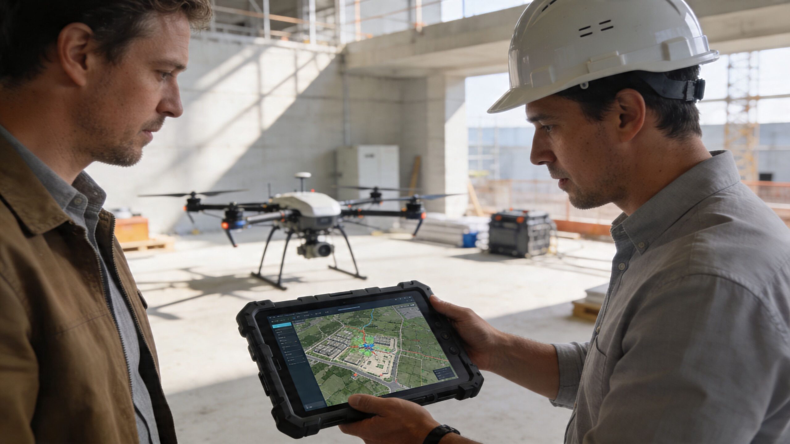
Here’s a useful visual example of how drone workflows support construction planning and review:
Processing and quality control
After capture, the image set goes into processing software such as DroneDeploy, Agisoft Metashape, RealityCapture, or Pix4D. From there, the team builds orthomosaics, surface models, point clouds, and other outputs defined in the original brief.
Processing is not a push-button exercise. Alignment has to be checked. Coverage gaps have to be caught. Edges, soft areas, and reconstruction artifacts need review before anything reaches the client. A survey intended for BIM coordination has to hold up under measurement. A survey intended for planning or investor review also has to read clearly, which means the visual exports need order, legibility, and a point of view.
Delivery and review
The handoff should help the project team act quickly.
That usually includes mapped exports, point cloud files, browser-based viewers, selected stills, and concise notes on what each file is for. The best deliverables are organized around use, not around the software that created them. Architects should be able to pull what they need for design. Contractors should be able to review current conditions without hunting through folders. Owners and consultants should be able to understand the site without needing a technical translator.
That is the full workflow in practice. Careful scoping, disciplined capture, rigorous processing, and a clean handoff. The result is not just accurate site information. It is a measured visual record that supports design judgment, coordination, and presentation at the same time.
Integrating Survey Data with Your Design and Build Process
Drone data becomes valuable when it leaves the export folder and enters the daily workflow. That’s the real test. If the files can’t inform design, coordination, or field decisions, the flight was only partially successful.
For architects and designers
Architects usually get the most immediate value from orthomosaics and point clouds. The orthomosaic becomes a clean reference layer for understanding site context, access, hardscape, vegetation, and adjacent structures. The point cloud brings the site into design software as measured reality.
In practice, that means teams can import data into Revit, AutoCAD, or related tools and work against actual conditions instead of assumptions or stitched-together references. Existing grade relationships become easier to read. Rooflines, wall conditions, and site edges can be reviewed with much more confidence. For presentation work, the same data also supports more believable context models and stronger visualizations.
For contractors and field teams
Contractors tend to use the data more operationally. DEMs support grading reviews and earthwork decisions. Point clouds and models help teams compare current conditions against expected conditions. Repeated flights create a visual record that is hard to argue with because everyone can see the same site state from the same vantage logic.
That’s one reason drone capture pairs so naturally with construction progress photography. The still photography tells the human and material story at ground level. The aerial survey shows the broader site logic, sequencing, and project trajectory.
A field report tells you what happened. A well-timed aerial survey helps explain why it happened where it did.
For developers and owners
Developers and owners often need a different kind of clarity. They need materials that travel well across meetings. A point cloud might matter to the design team, but an owner presentation often benefits more from a legible orthomosaic, a clean 3D site view, and editorial-style aerials that show frontage, access, and context.
That’s where the blend of surveying and photography really earns its place. A single flight campaign can support technical review and stakeholder communication, but only if the operator understands both audiences. Data alone can be opaque. Beautiful images alone can be vague. The useful middle ground is visual information that reads quickly and holds up under scrutiny.
A practical integration checklist
- Match outputs to software: Confirm the architect or contractor can ingest the requested file type before the flight.
- Define the decision: Ask what the team needs to verify, compare, or present.
- Separate technical and editorial needs: They often happen on the same day, but they require different flight priorities.
- Plan for repeatability: If the site will be flown again, keep views and coverage consistent enough for comparison.
That last point matters more than many teams expect. Repeatable visual logic is what turns isolated flights into a useful project record.
Navigating Regulations and Ensuring On-Site Safety
Drone surveying on an active site is not just a technical task. It’s an operational one. The pilot has to protect workers, equipment, property, and the client’s risk profile while still collecting usable data.
What compliance looks like in practice
In the United States, commercial drone work falls under FAA Part 107. That means the operator needs to understand the rules governing commercial flight, airspace, site conditions, and operating limitations. On a dense urban project, this becomes more than paperwork. It affects scheduling, feasibility, and insurance.
According to Wingtra’s surveying guidance, dense urban environments like Atlanta add serious complexity because of FAA Part 107 rules, no-fly zones near airports, and 2026 Remote ID mandates, with insurance premiums for urban operations rising by 35%.
That matters in places where projects sit near controlled airspace or where crane activity, adjacent buildings, and pedestrian movement tighten the margin for error.
Why active construction sites need stricter discipline
Construction sites change daily. That means yesterday’s safe launch point might be today’s material laydown area. A path that looked clear in pre-planning may now intersect with lifts, delivery routes, or new overhead hazards.
A responsible operator should account for:
- Worker awareness: The superintendent and key site personnel should know when and where the drone will operate.
- Launch and recovery zones: These should be controlled, visible, and kept clear of foot traffic.
- Airspace and proximity issues: Especially near airports and in complex city environments.
- Liability coverage: Insurance should fit commercial operations, not hobby use.
- Mission limits: If the conditions are wrong, the right call is to delay the flight.
The due-diligence questions clients should ask
If you’re hiring a provider, ask direct questions.
- Are you licensed for commercial drone operations under Part 107?
- Do you carry insurance appropriate for urban and active-site work?
- Have you flown in comparable airspace and construction conditions before?
- What is your site-safety protocol before takeoff?
- How do you coordinate with the superintendent or owner representative on site?
Compliance isn’t an extra service. It’s part of the deliverable.
The best operators don’t treat regulations as a nuisance. They treat them as evidence of professionalism. That’s good for everyone on the project.
Partnering for Success Choosing Your Drone Photographer
A developer is reviewing early massing options on Monday, a lender package on Wednesday, and a marketing deck by Friday. The aerial work needs to hold up in all three rooms. That is where provider choice starts to matter.
More firms now offer drone services, which makes vetting more important, not less. A capable survey operator can fly a grid and process a map. A capable architectural image-maker can show scale, context, and design intent. On the best projects, you need both skills in the same set of hands.
That distinction gets missed often. I see it when a team receives technically usable files that are hard to present, or polished aerials that fall apart the moment an architect asks for alignment, coverage, or repeatability. Good drone surveying for architecture sits in the middle. It produces dependable data and imagery that communicates clearly to clients, planners, and design teams.
The difference between a pilot and a visual professional
Flying the aircraft is only one part of the assignment. The stronger hire understands built form, site hierarchy, light direction, lens behavior, and how aerial frames relate to ground-based coverage. They know when a roof plan needs neutral, legible coverage and when a hero angle should explain adjacency, access, and massing in one frame.
That is why portfolio review matters. A strong body of work from a commercial architectural photographer shows whether the provider can read architecture instead of passively recording it.
Questions worth asking before you hire
Use the interview to test judgment, not just equipment ownership.
- What do you routinely deliver? Ask about orthomosaics, DEMs, point clouds, measured overlays, and presentation-ready stills.
- What processing and export tools do you use? The answer should connect software choices to the files your architect, civil team, or contractor needs.
- How do you check accuracy and image quality? Look for a defined QC process, including overlap review, control workflow if used, and file inspection before delivery.
- Can you show work from active construction sites and completed architecture projects? Those assignments require different timing, framing, and client communication.
- How do you separate documentation images from editorial images? The right provider knows these serve different purposes, even when captured on the same flight.
- What will the final package look like for each stakeholder? Owners, design teams, and marketing staff rarely need the same files arranged the same way.
What quality usually looks like
Quality is usually quiet. It shows up in files that are easy to use and images that explain the project without forcing the viewer to work for it.
Look for:
- Controlled geometry: Building lines, horizon placement, and spatial relationships should feel deliberate.
- Clear site explanation: Coverage should clarify access, setbacks, grading, context, and progress.
- Technical fluency: The provider should explain outputs plainly and know where the limits are.
- Visual judgment: Light, shadow, weather, and season should support the purpose of the assignment, not fight it.
If one provider handles measurement and communication well, the project stays cleaner from review through presentation.
That saves more than production time. It reduces handoff errors, avoids duplicate flights, and gives the team one visual language across planning, design, approvals, and stakeholder updates. For high-value projects, that consistency is part of the service.
A New Perspective on Project Intelligence
Drone Photography for Site Surveying has matured into something much more useful than a fast aerial photo service. It gives project teams a way to understand land, progress, logistics, and design context with far more clarity than ground-only documentation can usually provide on its own.
The technical side matters. Orthomosaics, DEMs, and point clouds support real work. They guide planning, coordination, grading, and progress review. But the visual side matters too. A site is not just a measured surface. It is also a story about approach, adjacency, scale, and intent.
That’s why the strongest drone work in architecture and construction does two jobs at once. It creates dependable project intelligence, and it translates that intelligence into images people can read quickly. That combination helps architects design with better context, helps contractors manage with better visibility, and helps developers present with more confidence.
The aerial view isn’t valuable because it’s dramatic. It’s valuable because it turns scattered site conditions into a coherent picture. When that picture is both accurate and well seen, better decisions tend to follow.
If you need Drone Photography for Site Surveying that balances technical rigor with design-forward imagery, Jimmy Clemmons Photographer brings an architectural photographer’s eye to aerial documentation, site intelligence, and polished visual storytelling for architects, developers, and builders.