

You're probably here because you need more than a pretty skyline shot. Maybe you're an architect trying to show how a building sits in its neighborhood. Maybe you're a developer who needs investor-ready views that explain access, scale, and surrounding context in one frame. Or maybe your marketing team searched for Atlanta aerial photos and got buried in stock-image galleries, random drone operators, and archive sites that don't tell you what's useful.
That confusion is normal. In Atlanta, “aerial photos” can mean three very different things. It can mean stock imagery for editorial mood, historical archives for site history and land-change research, or custom-commissioned photography created for a specific project and business use. Those are not interchangeable, and treating them like they are is where most projects go sideways.
From a photographer's perspective, the essential task isn't getting a camera into the air. The crucial work is deciding what the image needs to say. Aerial work is strongest when it does two things at once. It documents a place accurately, and it gives that place a point of view.
Seeing Atlanta from a New Perspective
When clients ask me for Atlanta aerial photos, I usually slow the conversation down before I speed it up. The first question isn't about drones, altitude, or permits. It's this: what story does the image need to tell once someone sees it?
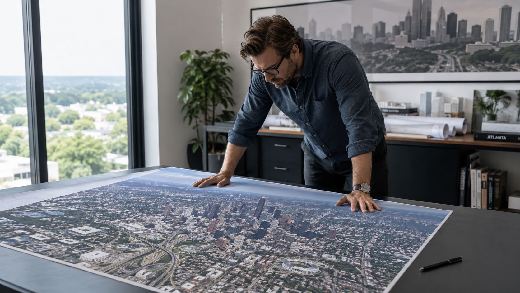
A hospitality group may need a broad establishing image that makes a property feel connected to the city. An architecture firm may need a more disciplined view that reveals massing, circulation, and the relationship between structure and site. A developer may need repeatable viewpoints over time so the image functions as both marketing and record.
That's why generic search results usually disappoint. Many search results for Atlanta aerial photos surface generic stock-image pages instead of a clear roadmap. The University of Georgia's Map and Government Information Library holds over 230,000 historical images in Georgia, while Fulton County offers modern orthoimagery, but most clients still don't get a practical comparison of archival, county, and museum options for commercial use in one place, as outlined by the UGA Map and Government Information Library aerial photo collection.
What clients usually need
The request often falls into one of these buckets:
- Context for design: Show how the building fits streets, topography, neighboring structures, and its surroundings.
- Progress documentation: Create a consistent visual record during construction or repositioning.
- Brand storytelling: Produce images that feel editorial, intentional, and usable across web, print, decks, and PR.
- Historical comparison: Pair current commissioned imagery with archives to explain how a site evolved.
I see the strongest results when aerial photography is treated like part of the larger visual narrative, not as an add-on. That's the same thinking behind thoughtful architectural landscapes in Atlanta. The image should do more than prove the building exists. It should explain why the place matters.
Practical rule: If you can't describe the image's job in one sentence, you're not ready to schedule the flight.
Phase One Defining Your Vision and Scope
Bad aerial shoots usually start with a vague request. “We need some drone shots” sounds harmless, but it creates expensive ambiguity. Good shoots start with a brief that names the subject, the purpose, the audience, and the final use.
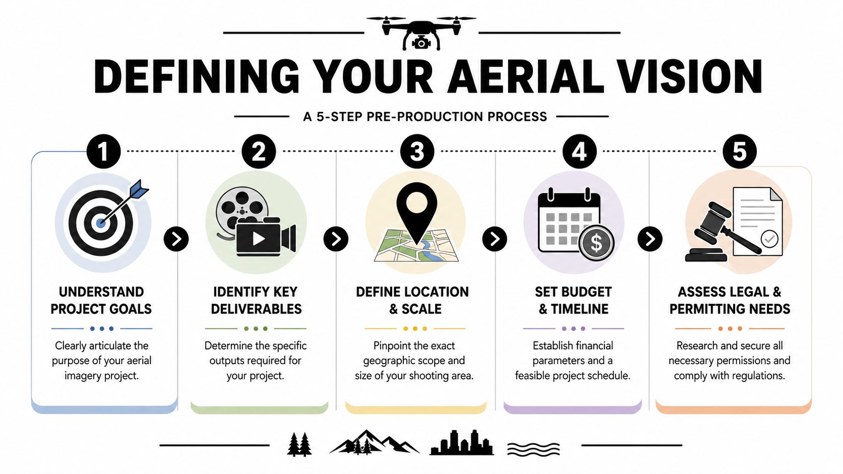
Start with the image's job
I like to pin the project to one primary function. Secondary uses can follow, but there needs to be one lead objective.
Finished architecture
The goal is usually form, site relationship, and design clarity. You're showing how the project lands in the city.Construction progress
Consistency matters more than drama. The same angle repeated over time usually beats a collection of unrelated hero shots.Development marketing
Context becomes part of the sales argument. Access roads, neighboring assets, green space, and urban connection all matter.Editorial or brand campaign
Here the image can be more atmospheric. You still need accuracy, but mood and graphic composition carry more weight.
Build the brief before the flight
A useful client brief doesn't need to be long. It needs to be specific.
Include these items:
- Exact subject: The building, campus, parcel, corridor, or district.
- Must-show features: Parking layout, façade orientation, public realm, rooftop amenities, transit adjacency, or construction status.
- Deliverables: Website hero crops, vertical magazine use, investor deck slides, print spreads, signage, or award submissions.
- Visual direction: Clean and diagrammatic, warm and editorial, dramatic twilight, or neutral documentation.
- Usage realities: Internal reporting, public marketing, licensed commercial use, or archival record.
The quality of this brief affects everything after it. It influences platform choice, timing, permits, route planning, and post-production.
Use history to sharpen the present
Some of the smartest pre-production work happens before anyone launches a drone. In Atlanta, historical context can materially improve the brief. Georgia State University preserves a 1949 aerial survey of the Atlanta Metropolitan Area, and tools like ATLMaps, a collaboration between Georgia State University and Emory University, make it practical to layer historical material to understand site evolution, as shown in the 1949 Atlanta Metropolitan Area aerial survey record.
That matters more than people think. If a client is redeveloping a corridor, repositioning a legacy property, or presenting a project to a neighborhood group, historical aerials can reveal street changes, land use shifts, erased infrastructure, and the larger logic of the site.
Historical reference doesn't just support research. It often tells you where your strongest current photograph should stand.
Scope affects cost even when the creative idea stays the same
Two projects can want the same visual feel and still require very different production plans. A single-building commission near unobstructed airspace is a different assignment from a multi-site campaign across dense urban zones. The mistake is assuming the camera is the main variable. Usually it isn't. Access, timing, approvals, and repeatability shape the assignment just as much.
A clear scope also keeps everyone honest about what “coverage” means. If the client wants broad context, detail views, construction sequence, and branded hero images, that's not one shot list. That's several.
Choosing Your Platform Drones vs Crewed Aircraft
The platform changes the look. It also changes the workflow, the permits, the flexibility on site, and the kind of story you can tell. I don't treat drones and crewed aircraft as competitors. I treat them as different lenses on the same assignment.
Where drones win
For most architecture and commercial brand work, drones are the more nimble tool. They let you work low, shape perspective carefully, and stay close enough to a building for form and material to read clearly. That's especially useful when the assignment needs:
- Façade-forward views that still show site context
- Rooftop and courtyard angles that are impossible from the ground
- Lower-altitude storytelling where the neighborhood needs to feel connected, not distant
- Repeat visits for construction or phased development
Drones also make it easier to refine a composition in real time. You can adjust a few feet, a little left, a little higher, and see the design resolve. For visual storytelling, that control matters.
If your use case leans toward site analysis and documentation, this companion piece on drone photography for site surveying covers that side of the conversation well.
Where crewed aircraft win
Crewed aircraft are still the right answer for some projects, especially when the image needs to express metropolitan scale instead of architectural intimacy. Professional aerial mapping methods used by NOAA often involve capturing imagery from aircraft at about 10,000 feet above ground level, with each frame spatially referenced by GPS for map-grade positional use, according to NOAA's aerial photography overview.
That standard matters because it shows what airplanes do well. They cover broad areas efficiently, maintain consistent geometry, and support work where spatial reference and wide-area continuity matter more than low-altitude nuance.
Here's the simple comparison:
| Platform | Best fit | Visual character | Common trade-off |
|---|---|---|---|
| Drone | Architecture, hospitality, marketing, progress views | Immersive, close, sculptural | More constrained by local airspace and site obstacles |
| Crewed aircraft | Regional context, corridor studies, large campuses, map-grade coverage | Expansive, geographic, system-level | Higher coordination burden and less fine-grained repositioning |
A short visual comparison helps if you're weighing both options:
What doesn't work
The wrong choice usually shows up in one of two ways.
- Using a drone when the assignment needs scale: The images feel attractive but small. They don't explain the project's relationship to the larger city.
- Using a crewed aircraft when the assignment needs design intent: The building turns into a dot in a big frame, and the architectural story disappears.
If the client says, “We need to show the whole district,” I start evaluating aircraft. If they say, “We need the building to feel intentional in its context,” I usually start with a drone.
One practical note. Aerial imagery for commercial work often sits between documentation and art direction. That's where an architectural photographer, a licensed drone operator, or a studio such as Jimmy Clemmons Photographer can be useful, because the assignment isn't just flight execution. It's composition, timing, editing, and matching the final images to the project's actual use.
Navigating Atlanta's Airspace Legal and Permit Essentials
Atlanta is a rewarding city to photograph from the air, but it isn't casual airspace. If your site sits near dense urban corridors, event zones, or airport influence, the legal side shapes the creative options quickly.
The part clients should understand
You don't need to become an FAA specialist to commission aerial work well. You do need to understand that location controls possibility. The same building photographed in open suburban airspace and inside restricted urban airspace can involve very different timing, altitude limits, and approval steps.
That affects practical things clients care about:
- Golden-hour timing: Beautiful light may not line up neatly with an approved flight window.
- Maximum workable altitude: Your preferred framing may not be possible from the height you imagined.
- Schedule reliability: A simple weather move can become a permit issue if the site requires new coordination.
- Crew choice: Some assignments are legally easy but creatively hard. Others are creatively simple but administratively demanding.
Why Atlanta takes planning
The airspace picture around Atlanta is shaped by active aviation, dense development, and location-specific restrictions. That doesn't mean a shoot can't happen. It means a professional has to evaluate the site before promising a shot.
I've found clients are most frustrated when they approve a concept image before anyone checks airspace realities. A rooftop perspective may be legal. The exact wider pullback that makes it sing may not be. That's why preflight research matters as much as camera craft.
A good operator will typically check:
- Site coordinates and surrounding airspace
- Nearby airport influence
- Temporary restrictions or event impacts
- Launch and recovery practicality
- People, traffic, crane, and obstacle exposure
- Property access and owner permissions
Permits are not the whole story
People often use “permit” as shorthand for the entire legal process, but that's too broad. You may need airspace authorization, property permission, site coordination, insurance documentation, and a practical safety plan. Missing any one of those can disrupt the assignment.
Some locations are technically flyable but operationally poor. Heavy pedestrian traffic, reflective façades, active construction, or limited staging areas can turn a legal flight into a weak creative environment.
The cleanest legal approval in the city won't rescue a bad launch point or a crowded site.
What helps the process move smoothly
Clients can make this easier by bringing useful information early.
- Share the exact address and a site pin: “Midtown” isn't enough.
- Send a simple property map or rendering: It helps identify intended angles before permit work begins.
- Name any hard deadlines up front: Investor meetings, publication dates, and opening events change the planning rhythm.
- Mention stakeholders: Property managers, GCs, security teams, and agency reviewers all affect access.
The best aerial assignments in Atlanta feel calm on shoot day because the complexity was handled earlier. That's what you're paying for. Not just a flight. Judgment.
The Shot List From Blueprints to Breathtaking Photos
A strong shot list keeps the assignment from drifting into random coverage, making the work photographic rather than merely operational. The camera goes up with intent, not hope.
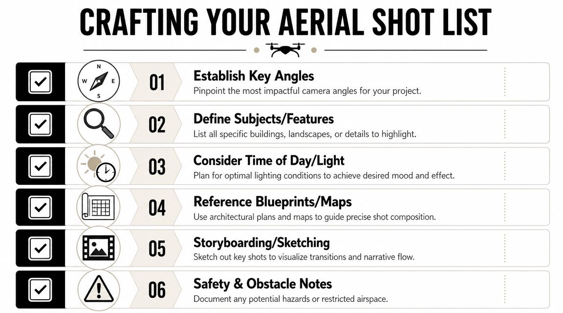
For architects
Architects usually care about geometry, orientation, and how the building sits in the site. Their shot list should reflect that precision.
A typical architecture-oriented list might include:
- Plan-like high oblique: High enough to understand the building footprint and circulation.
- Corner view with depth: Useful when massing and façade transitions matter.
- Roof and surrounding area integration: Especially important for hospitality, mixed-use, and institutional projects.
- Sun-angle composition: Early or late light that reveals texture, shadow, and volumetric form.
I often ask for blueprints, elevations, or site plans before the shoot. Those documents reveal the design intent. They tell you which side represents the core architectural design.
For developers and property teams
Developers tend to need a more hybrid set of images. The building matters, but so do access, amenities, and market context.
A practical developer shot list often includes:
- Hero context view showing the property's relationship to key roads and surrounding assets
- Approach sequence that mirrors how a tenant, investor, or visitor experiences arrival
- Amenity adjacency such as green space, retail frontage, or neighboring anchors
- Repeatable progress angle for future comparison
For this reason, aerial images become persuasive. A single frame can show land use, connectivity, and positioning better than several ground photos.
For corporate and brand teams
Brand teams usually need images that can crop in multiple directions without losing impact. They need room for headlines, website banners, annual reports, and campaign layouts.
That changes the shot list. You start thinking less like a surveyor and more like an editor.
Consider these asks:
- Wide negative-space composition for website headers
- Vertical skyline-context frame for print and presentation use
- Twilight or blue-hour option for premium brand feel
- Clean top-down graphic frame for social, collateral, or motion design
A shot list should include the frame you know you need and the frame your designer will wish you had six months later.
What I watch on site
Even with a prepared shot list, the final image often comes from a live adjustment. Maybe the light shifts, maybe traffic patterns strengthen the composition, maybe a façade catches reflection better from a slightly different axis.
That's why I don't treat the shot list as a rigid checklist. I treat it as a disciplined starting point.
Three things usually improve the final set:
- Light direction over convenience: Midday may be easy, but it rarely flatters architecture.
- Layering over altitude alone: A better image often comes from a smarter relationship between foreground, subject, and city beyond.
- Consistency when documenting change: If the project needs time-series comparison, improvisation has limits. Repetition matters.
The best Atlanta aerial photos feel inevitable after the fact. In reality, they came from careful prep, a disciplined list, and enough flexibility to recognize the stronger frame when it appears.
Beyond the Shoot Using Your Atlanta Aerial Photos
Once the flight is done, the assignment is only half finished. Raw captures rarely carry the full value on their own. Selection, sequencing, retouching, licensing, and delivery format determine whether the images become useful assets or just a folder of files.
What you should expect to receive
Commercial clients should ask for a clean deliverable package, not a loose dump of images. That usually means edited selects prepared for the uses named in the brief.
A practical delivery set may include:
- High-resolution master files for print and archival use
- Web-ready exports sized and sharpened for digital publishing
- Cropped variants for horizontal, vertical, and banner applications
- Consistent color and tonal work so the set feels unified
- Naming and organization that a marketing or design team can use
Retouching matters more in aerial work than many clients expect. Haze, color contamination, distracting vehicles, patchy pavement, and uneven rooftop surfaces can all pull attention away from the subject. The goal isn't fake perfection. The goal is clarity.
The images can serve more than marketing
The use of aerial imagery in Atlanta is shifting from purely marketing visuals to decision-grade data. The USGS Atlanta airport land-cover example and Fulton County's 2024 orthoimagery portal show how high-resolution aerials now support documentation, planning, and change detection, as reflected in the USGS Atlanta airport aerial photography land-cover example.
That's an important shift for architecture, development, and institutional clients. Aerial images can now live in more than one lane at once.
Where clients get the most value
I see the strongest long-term use in a few places:
Investor and leasing decks
Aerials explain access, surroundings, and scale faster than dense site diagrams.Award submissions and editorial packages
Strong aerial views help juries and editors understand the design in context.Website and campaign systems
One well-produced aerial can anchor a whole launch sequence across homepage, social, and PR.Planning and internal documentation
Repeated views become a visual record for repositioning, expansion, and site management.Wall installations and branded interiors
In offices, campuses, and sales centers, aerial work can reinforce identity and place.
Licensing should be handled just as carefully as the shoot itself. If the images will circulate across campaigns, investor materials, earned media, and long-term brand use, get clear on rights early. This guide to licensing a photo for commercial use is a useful starting point.
What makes the commission worth it
Aerial photography pays off when the pictures keep working after the launch announcement is over. That usually comes down to three decisions made early:
| Decision | Weak version | Strong version |
|---|---|---|
| Creative brief | “Get some drone shots” | “Show this project's relationship to the neighborhood and main approach corridors” |
| Platform choice | Cheapest available aircraft | Tool matched to the story and site |
| Delivery plan | Generic image folder | Edited files built for specific commercial uses |
That's why I see aerial assignments as strategic visual work, not novelty production. The strongest Atlanta aerial photos don't just decorate a presentation. They explain a place, support a business case, and hold up over time.
If you need Atlanta aerial photos that balance architectural clarity with narrative value, Jimmy Clemmons Photographer handles commissioned imagery for architecture, commercial property, and brand teams who need more than generic coverage. Bring the site, the brief, and the intended use. The rest of the process gets much easier when the photography starts with a clear point of view.