

The best drone image I made for a developer wasn't the highest flight or the widest view. It was a low, deliberate frame taken just above roofline, where the new building finally locked into the street grid and made the architect's intent obvious. That's the difference between flying for novelty and flying for purpose.
Drone photography has moved well beyond simple high-angle snapshots. In commercial work, a strong aerial frame explains design intent, site logic, circulation, risk, scale, and atmosphere in one read. The market has followed that shift. Fact.MR values the global drone photography services market at USD 870 million in 2025, with strong projected growth through 2035, which tracks with what many of us see in practice: clients no longer treat aerials as a nice add-on. They expect them.
That expectation also reflects a longer history than is commonly understood. Camera-equipped drone imagery didn't begin as a lifestyle tool. The National Air and Space Museum's history of drones traces it back to military reconnaissance, including more than 9,400 OQ-3 target drones built during World War II and about 1,000 AQM-34 drones flying more than 34,000 surveillance missions between 1964 and 1975, with 83% returning for reuse. The roots of today's drone with camera images are in repeatable observation and dependable data capture.
That's why this isn't just a gallery. These are ten image types I'd build into a commercial shot list, each with the brief behind it, the compositional logic, the flight approach, the client use, and the delivery decisions that make the image valuable after the drone lands.
1. Aerial Architectural Photography
This is the assignment often thought of first, and it's still where many of the best drone with camera images earn their keep. The brief is rarely “get something dramatic.” It's usually “show the building clearly, make the design legible, and place it in context.”
For a mixed-use project, I'll usually start with a medium altitude pass instead of going immediately high. That height lets the façade, entry sequence, sidewalks, and neighboring massing all read in one frame. Go too high and the building turns into a roof plan. Go too low and you lose the site relationship.
How I Build the Frame
I look for one primary story. On a hotel, it might be arrival and amenity adjacency. On a corporate campus, it might be how separate buildings form a coherent environment. On a multifamily development, it's often the transition from public street to private courtyard.
A practical flight pattern often looks like this:
- Low establishing pass: Capture a near-elevational view that preserves vertical lines as much as possible.
- Mid-height context pass: Show how the structure sits on the block or in its surroundings.
- Higher overview pass: Reserve this for planning, portfolio spreads, or board presentation use where context matters more than façade detail.
Clients often benefit from seeing Atlanta aerial photography examples in a commercial portfolio because it clarifies how subtle altitude changes can shift an image from marketing piece to design document.
Practical rule: If the architect cares about the façade articulation, don't let the roof dominate the frame.
For technical settings, I favor a focal length that doesn't exaggerate corners, manual exposure, and a shutter speed fast enough to keep detail crisp when the drone is holding position in light wind. Altitude is dictated by airspace, surroundings, and the building's scale, not by a fixed formula. Delivery usually includes layered exports: web-ready JPEGs for marketing, high-resolution files for print, and cropped alternates for vertical placements.
Licensing matters here. Aerial exteriors often end up in ad campaigns, investor decks, leasing brochures, editorial submissions, and signage. Spell that out at delivery so the client isn't guessing later.
2. Construction Progress Documentation
Construction aerials are about consistency more than flair. The strongest progress set is often the least flashy one because every frame is built for comparison. Same vantage. Same height. Same lens. Same time of day, if possible.
Near the start of a progress assignment, I'll create a repeatable flight plan and lock it down before the site gets complicated.
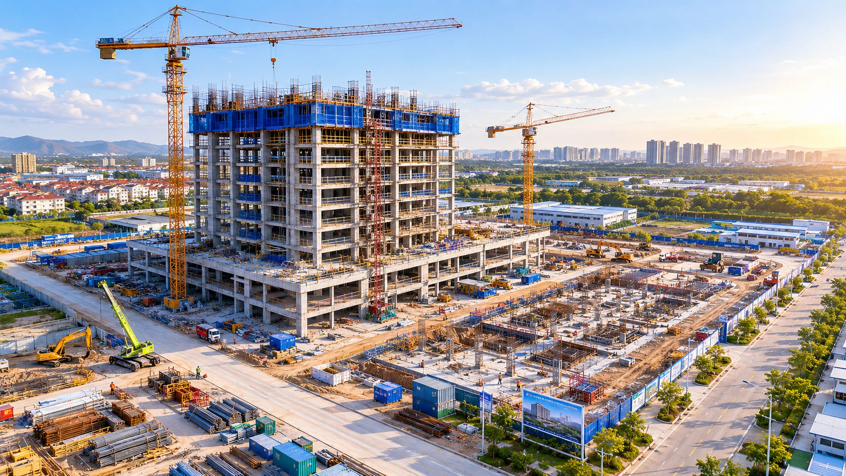
The reason clients keep paying for this work is simple. In a 2024 construction-focused case study summarized in an academic review, drones used for site monitoring were reported to reduce life-threatening accidents by up to 91% while also collecting millions of data points per flight for takeoffs, tracking, and dispute resolution. Even when I'm shooting stills for communications, that same logic shapes the flight. Aerial visibility changes how teams understand the site.
What Actually Works on Active Sites
The best progress imagery usually includes three layers of information: the overall footprint, the current structural milestone, and evidence of activity without visual chaos. I want cranes, laydown yards, circulation routes, and key installed systems to read clearly.
What doesn't work is chasing “epic sunset construction shots” every month if the brief is documentation. That creates a beautiful but inconsistent archive. Stakeholders lose the ability to compare phases cleanly.
A solid delivery package usually includes:
- Matched monthly hero frames: For side-by-side milestone comparison.
- Detail selects: Mechanical zones, façade progress, roofing, utility trenches, or staging changes.
- Captioned filenames: Month, phase, orientation, and building ID, so the image library stays usable.
Later in the reporting cycle, motion often helps sell the transformation story to investors and the public. A simple embedded example belongs after the stills strategy, not before it.
For motion reference, this kind of pacing is often what clients want in marketing recaps:
Licensing here is narrower than in lifestyle marketing. Most contractors and developers need internal reporting, presentations, PR, and social distribution. If an agency might repurpose the archive into paid media later, define that before the shoot.
3. Interior Spatial Documentation
Interior drone work is less forgiving than exterior work. GPS may be unreliable, reflective surfaces can confuse obstacle systems, and one bad prop wash decision can turn a polished lobby into a wind machine. Still, for atriums, hotel lobbies, warehouses, and large public interiors, a carefully flown drone can reveal spatial hierarchy in a way ground photography can't.

The brief is usually about flow. Show how the mezzanine relates to the lobby, how seating clusters anchor the room, or how circulation leads a visitor from entry to reception to destination.
The Interior Trade-Off Nobody Mentions
A drone gives you viewpoint access, not lighting control. That matters because interiors often combine window glare, mixed fixtures, dark finishes, and bright signage. In lower or variable light, the best-supported beginner guidance is to control exposure, use bracketing, and stitch panoramas carefully rather than assuming one frame will solve everything. That's a useful reminder from this beginner guide to drone photography and difficult light.
In practice, that means I don't force a single heroic exposure when the room won't support it. I'd rather build a cleaner stitched view than deliver a muddy file with blown windows.
Interior drone work fails when the pilot flies first and reads the room second.
My preferred approach is to prewalk the route, identify hanging fixtures, banners, sprinklers, and polished surfaces, then plan one or two stable hover positions instead of wandering. For technical settings, I prioritize manual white balance consistency, lower movement speed, and bracketed captures when dynamic range is tricky.
Delivery is usually split two ways. Designers want clean, descriptive files for portfolios and award submissions. Operators may want frames annotated by zone for space planning or facility communication. License those uses clearly, especially if a hospitality client also wants ad placement rights.
4. Site Planning and Landscape Context
Some of the most useful drone with camera images don't center the building at all. They center the site. Site architects, planners, civil teams, and developers often need the image to explain grading, circulation, planting structure, public space hierarchy, and how built elements sit inside the larger environment.
When the assignment leans planning-heavy, I'll photograph the same property very differently than I would for a leasing brochure. I'm less interested in a dramatic oblique and more interested in views that show paths, drop-offs, parking relationships, tree canopies, stormwater features, and outdoor gathering zones in one logical read.
Why Height Choice Changes Meaning
A low oblique frame can make a plaza feel intimate and premium. A higher frame can make the same plaza legible as part of a circulation system. Neither is more correct. The wrong choice is using one when the client needs the other.
This is where drone photography for site surveying becomes a useful reference point. Planning images need to feel orderly and dependable. Even when they're visually polished, they should still help a client answer practical questions about access, boundaries, and design intent.
A few field rules keep these frames useful:
- Photograph at multiple heights: One image for human experience, one for spatial logic.
- Watch seasonal timing: An outdoor project can look underdeveloped if shot before planting fills in.
- Simplify clutter: Temporary fencing, parked service vehicles, and patchy maintenance can distract from the design story.
Licensing and delivery often expand here. A developer might use the work in entitlements, community presentations, investor materials, and long-term portfolio documentation. Provide clean master files plus crops that isolate key site zones for presentation decks.
5. Rooftop Condition and Equipment Documentation
Rooftop work is where drone photography stops being mostly expressive and becomes operational. The client isn't asking for atmosphere. They want answers. Is the membrane intact? Are units accessible? Has storm damage spread? Where exactly is the equipment bank in relation to drains, parapets, and service paths?
This category reflects one of the reasons industrial drone imaging has grown beyond simple photography. In enterprise inspection and mapping workflows, DJI's Matrice 350 RTK and Matrice 400 RTK platforms are paired with payloads like the Zenmuse H30 and Zenmuse L2 to capture wide-angle, telephoto, orthomosaic, 3D model, and LiDAR outputs for inspection and mapping tasks, as shown in DJI's enterprise workflow overview. Even when a smaller aircraft handles a simpler roof assignment, that same mindset applies. The image has to support action.
What Clients Need From the File Set
Property managers and facility teams usually need two kinds of images. First, overall roof diagrams that show system placement. Second, close detail frames that document condition, access constraints, and suspected issues.
A good rooftop package might include:
- Overview frames: Entire roof planes with major equipment labeled by location.
- Condition details: Flashing, seams, ponding areas, penetrations, and visible impact points.
- Access context: Ladders, hatches, edge clearances, and service routes.
The trade-off is compression versus clarity. Higher altitude makes layout obvious but can flatten condition clues. Lower altitude helps maintenance teams but loses the whole-system view. I nearly always deliver both.
A roof inspection image isn't finished when it looks good. It's finished when a facilities team can act on it.
Licensing is usually practical and internal, but don't assume that means simple. Insurance adjusters, engineers, roofing vendors, and ownership groups may all need access. Organize exports by roof section and building ID so the archive can survive beyond the person who ordered the shoot.
6. Urban Context and Streetscape Photography
Urban aerial work is about restraint. The city already gives you density, texture, and movement. Your job is to show how one property belongs to that fabric without making the frame feel chaotic.
For adaptive reuse, mixed-use, retail, and hospitality projects, I often treat the drone like a high movable balcony rather than a flying billboard machine. Mid-level obliques tend to be more persuasive than extreme altitude because they keep storefronts, sidewalks, neighboring façades, and public life in the same visual sentence.
Reading the Street From the Air
The first question I ask is whether the client needs urban energy or urban clarity. Those aren't the same. A marketing team may want pedestrians, traffic flow, and visible activation. An architect may want the setback, cornice line, streetscape improvements, and adjacency to read cleanly.
That decision affects everything:
- Busier hour: Better for showing vitality, hospitality use, and foot traffic patterns.
- Quieter hour: Better for clean façades, less curb clutter, and clearer design lines.
- Slightly off-axis composition: Often better than dead-on alignment in dense streets because it reveals depth without hiding storefronts.
What doesn't work is climbing too high and reducing the project to a pin on a map. In city work, context has to remain readable at human scale.
Licensing here often broadens fast. The same image might run in a leasing brochure, urban planning submission, magazine story, or social campaign. Deliver both editorial-style crops and ad-friendly negative-space versions. Cities are messy. Clean options save the client time later.
7. Before-and-After Renovation Documentation
Transformation photography depends on discipline. If the before image is casual and the after image is polished, the comparison feels dishonest even when the renovation is strong. Matching perspective is what gives the story credibility.
For renovation and adaptive reuse projects, I'll usually mark the original launch point, camera height, lens choice, and compass orientation in my notes. If the site allows, I'll also preserve the same time-of-day window between shoots so shadows don't become the story.
Consistency Sells the Change
The strongest before-and-after drone with camera images show more than a fresh façade. They reveal what changed in the building's relationship to its site. New entries, reworked site edges, upgraded circulation, roof interventions, added amenities, and improved street presence are often more persuasive than the finish materials alone.
A reliable renovation set should include:
- One hero comparison: Same frame, same geometry, obvious transformation.
- One context comparison: Show how the property sits differently in its block or campus.
- One functional comparison: Access, parking, grounds, or public realm improvement.
I'd avoid overprocessing the after files. Heavy skies, exaggerated saturation, and dramatic contrast can make a real improvement feel like a visual trick. Let the renovation do the work.
Licensing is often multi-audience here. Architects want portfolio proof. Developers want leasing and investor material. Preservation and institutional clients may want historical archive value. Deliver side-by-side composites if requested, but also provide the standalone originals so designers and communications teams can build their own layouts.
8. Warehouse and Logistics Facility Documentation
Industrial properties reward clarity. A warehouse image has to communicate scale, truck access, dock configuration, trailer storage, employee parking, yard organization, and circulation efficiency fast. If the frame looks cinematic but hides the operational logic, it misses the brief.
These assignments often serve brokerage, tenant marketing, internal communications, or operations planning. The visual story is less about beauty in the traditional sense and more about order and capability.
The Right Height for Industrial Work
Too low and the building feels big but unreadable. Too high and the logistics dissolve into pattern. I prefer a layered set: one medium-high angle that shows the full site organization, then tighter views on dock walls, circulation lanes, and yard usage.
For active facilities, timing matters more than many photographers expect. A completely empty truck court can make a property look underused. A fully congested one can make it look dysfunctional. The sweet spot is controlled activity that proves the facility works.
A usable shot list often includes:
- Dock-side oblique: To show depth, bay count pattern, and trailer relationship.
- Campus overview: For multi-building parks and circulation logic.
- Access approach view: To show arterial proximity, entry sequence, and visibility.
Delivery should reflect operations. Label buildings, orientations, and major site zones in filenames. If the client manages multiple facilities, archive structure matters almost as much as the images.
Licensing usually combines marketing and internal use. That means crops should be practical. Wide overviews for brochures, tighter operational frames for presentations, and vertical crops for digital listings.
9. Hospitality and Resort Property Marketing
Hospitality aerials have to sell experience, not just acreage. The best resort image doesn't merely show a pool, beach, spa, or golf edge. It lets a potential guest understand how arrival, privacy, amenities, and setting work together.
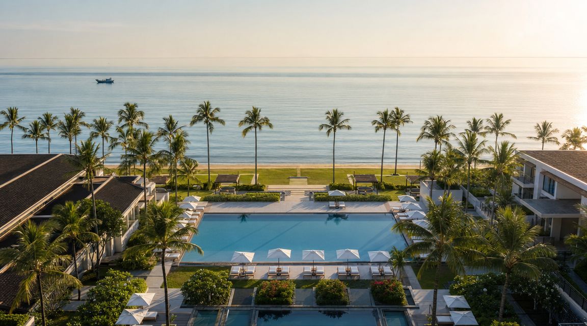
I usually build a hospitality flight around the guest journey. Approach view. Main amenity reveal. Relationship between rooms and surroundings. Signature aerial that says destination in one glance.
Marketing Beauty Versus Usable Coverage
Many shoots frequently drift into cliché. Sunset water, palm trees, and a high orbit can look attractive, but attractive isn't always persuasive. A booking team may need images that show pool adjacency to rooms, event lawn capacity, privacy buffers, or direct shoreline access.
Gear choices matter, but not in a gear-for-gear's-sake way. A client comparing deliverables should care more about sensor behavior in mixed light, clean color, and whether the files hold up in web banners, brochures, and print spreads. That's also why many teams spend time evaluating their broader real estate photography gear options before commissioning a property campaign.
Good hospitality aerials feel aspirational, but they still answer practical guest questions.
Privacy and licensing are especially important here. Hospitality properties often need web, social, OTA listings, ad campaigns, and editorial PR use. If guests or staff are visible, the delivery plan should reflect consent and commercial use requirements. Give the client hero retouched files plus cleaner utility views for sales and event teams.
10. Institutional Campus Master Planning Photography
Campus aerials have to do several jobs at once. They need to establish identity, show circulation, support planning, and communicate growth without turning the institution into an abstract map. Colleges, hospitals, civic campuses, and private schools all need that balance.
The assignment usually comes with competing priorities. Leadership wants a strong hero image. Facilities wants infrastructure legibility. Advancement wants beautiful storytelling. Enrollment or public communications wants the campus to feel active and welcoming. A thoughtful drone plan can serve all four if the frames are intentional.
Building a Campus Set That Lasts
I divide institutional coverage into three visual levels. Signature overview images establish the campus as a whole. Mid-level frames explain how major buildings connect through walks, roads, greens, and public spaces. Targeted frames isolate new construction, renovated wings, sports venues, or healthcare expansions.
A strong campus package often includes:
- Identity frame: Main entrance, central green, or signature building cluster.
- Planning frame: Circulation and building adjacency for board or facilities use.
- Recruitment frame: Human-scaled aerial with visible activity and welcoming light.
One practical issue matters more here than photographers sometimes admit. Not every campus image needs to be dramatic. Some need to be neutral, descriptive, and easy to annotate later. Those files often end up used the longest.
Licensing is usually broad. Institutional clients reuse imagery across fundraising, planning, press releases, viewbooks, websites, donor communications, and internal reports. Deliver a polished hero set, but also provide clean alternates with room for headlines, seals, or campaign copy.
10-Point Comparison: Drone Camera Imaging Applications
| Service | 🔄 Implementation complexity | ⚡ Resource requirements | 📊 Expected outcomes | 💡 Ideal use cases | ⭐ Key advantages |
|---|---|---|---|---|---|
| Aerial Architectural Photography | Moderate, Part 107, permits, weather-dependent | Pro/consumer drone, certified pilot, basic post‑processing | Elevated façades and context-ready images for presentations | Architectural portfolios, real estate marketing, design concepts | Reveals massing and context cost-effectively |
| Construction Progress Documentation | High, recurring flights, site safety and access coordination | Regular flights, data storage, timelapse software, GC coordination | Time-stamped progress records and timelapses for stakeholders | Project tracking, investor updates, legal documentation | Transparent progress tracking; early issue detection |
| Interior Spatial Documentation | High, indoor flight control, clearance, lighting constraints | Small agile drones, skilled pilot, site survey and lighting control | Overhead interior layouts and material/finish documentation | Large atriums, warehouses, hotels, interior design portfolios | Captures spatial flow and relationships not seen from ground |
| Site Planning and Landscape Context | Moderate, seasonal timing, permissions, shadow/vegetation factors | Multi-altitude flights, seasonal scheduling, mapping/post-processing | Topography, circulation, and landscape integration visuals | Landscape architecture, site planning, master plans | Communicates landscape integration and circulation clarity |
| Rooftop Condition and Equipment Documentation | Moderate, close inspection risks, wind exposure | High-res cameras, optional thermal sensors, cautious pilots | Detailed roof condition reports and equipment inventories | Facilities maintenance, insurance inspections, repair planning | Reduces safety risk; enables detailed remote inspections |
| Urban Context and Streetscape Photography | High, dense airspace, city permits, pedestrian safety | Experienced pilot, city coordination, timing to minimize clutter | Building-streetscape relationships and pedestrian activation views | Urban planning, zoning hearings, downtown marketing | Demonstrates neighborhood fit and street-level activation |
| Before-and-After Renovation Documentation | Moderate, repeat access, identical framing required | GPS/waypoints, scheduled captures across project timeline | Direct visual comparisons showing transformation and ROI | Renovation portfolios, restoration case studies, marketing | Powerful transformation narrative validating design impact |
| Warehouse and Logistics Facility Documentation | Moderate, security and operational coordination | Wide-area coverage drones, ops scheduling, stakeholder coordination | Facility footprint, loading/traffic flow and operational visuals | Supply chain marketing, tenant leasing, operational audits | Demonstrates operational scale and logistics efficiency |
| Hospitality and Resort Property Marketing | Moderate, guest privacy, seasonal/weather timing | Cinematic capture gear, golden-hour scheduling, management permits | Aspirational imagery highlighting amenities and setting | Resort campaigns, destination promotion, booking initiatives | Creates aspirational narratives that drive bookings |
| Institutional Campus Master Planning Photography | High, large-area coverage, multiple flights, security protocols | Extended flight time, varied altitudes, facility coordination | Comprehensive campus relationships and master-plan visuals | Fundraising, strategic planning, recruitment and marketing | Supports institutional storytelling and planning decisions |
From Image Capture to Client Value
The first time a client says, “We just need a few drone shots,” I know the deeper conversation has not started yet. By the end of the call, the useful questions are usually different. What decision does the image need to support? Who will use it? Does it need to sell, document, explain, or hold up under repeated reference over time?
Clients do not pay for altitude by itself. They pay for images that answer a business need with precision. A property owner may need clear proof of roof condition. A developer may need the site to read as organized, credible, and worth investment. An architect may need to show how a building sits in relation to the street, neighboring structures, and intended circulation. A marketing team may need files that work equally well in print, web, pitch decks, and signage without looking inconsistent from one format to the next.
That project brief drives every flight decision. Altitude affects readability. Camera angle changes whether the image feels analytical or promotional. Time of day controls shadow shape, window brightness, and how materials separate from each other. Lens choice, flight path, exposure control, and postproduction style should all serve the same end use. When those decisions are made in isolation, the client gets attractive files. When they are made as a system, the client gets images that keep solving problems after the shoot.
I see this gap often in mixed-use and architectural assignments.
A polished hero frame and a technically useful capture set are not always the same thing. Marketing images often favor selective angles, cleaner compositions, and light that flatters the structure. Documentation, measurement support, or 3D reconstruction usually require stricter coverage, repeatable overlap, and more disciplined shot planning. As noted earlier, oblique coverage matters when the goal extends beyond a simple top-down record. If that requirement is not defined before takeoff, the final gallery can look strong and still miss the deliverable the client needed.
Lighting creates the same kind of trade-off. Overcast skies can help with even facade detail. Late-day sun can give shape and warmth, but it can also bury parts of the site in shadow. Reflective roofs, bright windows, dark paving, and tight city blocks all push dynamic range hard. Good aerial work comes from planning around those limits, not expecting the drone to fix them later.
The value also shows up in parts of the job the client may never see directly. Airspace checks, takeoff location planning, safety protocols, scheduling around occupants or active operations, file naming, delivery structure, and licensing terms all affect whether the images are easy to use six months later. A strong shoot is not only well captured. It is well organized and clearly licensed for the people who need it.
That matters even more when drone images are only one part of the assignment. The best results come when aerials, ground-level stills, interiors, and detail images work together as one visual set. Then the project reads clearly across every client touchpoint, from a leasing brochure to a planning presentation to a long-term archive.
Partnering with a professional photographer like Jimmy Clemmons Photographer means the flight plan, composition, light, file prep, and usage strategy are handled as one process. That is how a drone image becomes more than a nice view. It becomes a working asset the client can reuse with confidence across marketing, documentation, and future project communication.